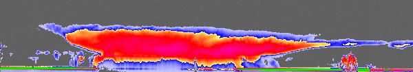
CloudSat flew over tropical storm Alberto as it spun over the Gulf of Mexico the morning of June 12, 2006. This image comparison shows how CloudSat "sees" such storms differently than conventional weather satellites. NEXRAD storm detection radar maps out precipitation patterns for up to 402 kilometers (250 nautical miles) from the coast. GOES satellites only sees the very top of the clouds, and cannot provide any detail about what is being seen beneath the cloud tops.

The CloudSat data show a smaller thunderstorm under the Alberto cirrus cloud cover. That storm is completely hidden from view in the GOES infrared image.

The CloudSat data show a smaller thunderstorm under the Alberto cirrus cloud cover. That storm is completely hidden from view in the GOES infrared image.
posted by Aerospace Bob at 10:41 AM
![]()

<< Home