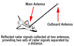
The most complete high-resolution topographic database of Earth came from the Shuttle Radar Topography Mission (SRTM) in February of 2000. SRTM consisted of a specially modified radar system that flew onboard the Space Shuttle Endeavour during an 11-day mission. There is an extensive on-line library of images of many countries. One of the more interesting items in this collection is an animation of what would happen to New O'rleans if a storm surge were to cause flooding. Go to this page and select Animation (Warning: It is a fairly large file).
posted by Aerospace Bob at 8:05 PM
![]()

<< Home